Have you ever thought about paddling 78 miles in 48 hours!? Jeannie Johns, an ultra endurance stand up paddler from British Columbia, Canada, who will be participating in the famous ultra 70-48 race next month shares her enthusiastic experience with the Paddle Logger app. During her paddling adventures around Gabriola Island, she highlights how the app simplifies trip tracking, offers valuable features like tide and wind information, and introduces her to the innovative PaddlePLAN®️ for route planning and waypoints. Jeannie appreciates the app’s safety features, especially PaddleLIVE®️, which provides peace of mind by allowing her to share her location and receive emergency alerts. She emphasizes how Paddle Logger has transformed her paddling routine into a more streamlined, safe, and enjoyable experience, making it her go-to tool on the water.
Hi Jeannie, welcome to TotalSUP today! We’re stoked to dive into all things Paddle Logger with you, while you prep for your big race! How do you typically use the Paddle Logger app during your paddling trips around Gabriola Island?
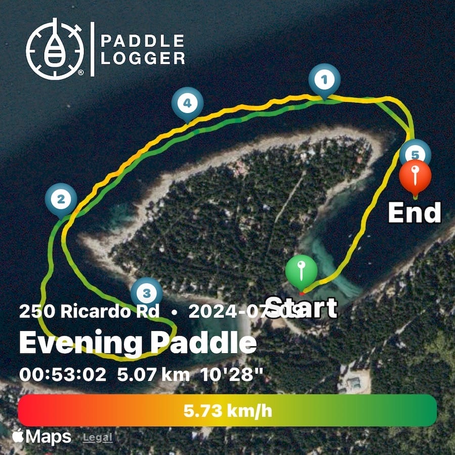
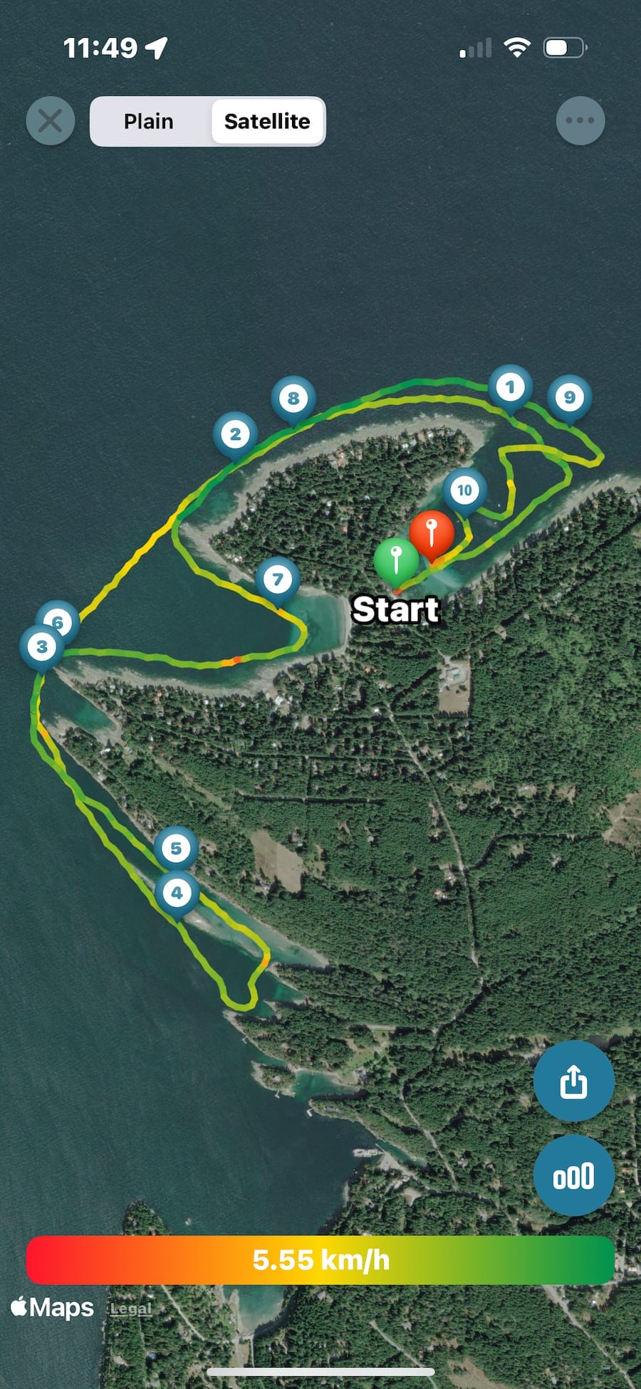
Typically I use the Paddle Logger app for all my paddling and training. I usually take the easy way and just press start, and Paddle Logger does the rest of the work tracking for me. For my training I use the race mode, it counts me down to start and will notify me of the end of that sprint or distance. I also love when I open the app and it tells me where my tides are and wind as well. Before I’d open several apps to check the different sea states. However with Paddle Logger, its all in one place! It makes me so happy.
Amazing! What features of the Paddle Logger app do you find most helpful when exploring Gabriola Island?
The most helpful feature that is new to me and I have only just begun venturing into it is the PaddlePLAN®️. I can pre plan a route and know distances and put waypoints along the way for where I may want to stop or be picked up. From there I can judge approx. time for travel and such as well. Excellent map of my area and it will keep me on course as I paddle as well. Paddling around Gabriola Island in British Columbia is an unforgettable experience filled with natural beauty. The calm waters, lush greenery, and rocky shoreline create a picturesque setting that feels almost magical. As you glide across the water, you can enjoy stunning coastal vistas, encounter playful marine life, and experience the tranquility of this pristine wilderness. It’s a truly breathtaking place to connect with nature and enjoy the serenity of the Pacific Northwest.
Gabriola is a small island where is sits among other islands, it is beautiful natural shore line along with the sea life you will encounter along your travels. There are campgrounds you can book and come into the site from the water, The natural made galleries of sandstone rock over hangs and sculpted rocks, peaceful surroundings on the ocean (not too much boat traffic in most areas of the island). The Island offers Leasure areas to paddle and advanced areas to paddle and prepare for that can be more challenging with tide and current for the very experienced paddlers. A beautiful place to visit and paddle.
That’s great! We love PaddlePLAN®️ too! It makes following routes so easy! Can you walk us through your usual process of recording a paddling trip with the app?
Honestly I am still exploring all the options Paddle Logger offers, but I love it. For my longer paddles I am loving the trip plan. I can pre plan, place waypoints and head out. Most often I press go and just head out, when I am done I have my travels and data about my paddle ready to view.
Incredible! How do you prepare with the Paddle Logger app before heading out on the water around Gabriola Island?
No prep needed unless it’s a new direction. Paddle logger keeps pre planned trips for future use. Just go and start your paddle. If I want a more accurate route to follow, I choose where on my map and place it into Paddle Plan and place my trip – easiest app I’ve ever used to plan a rip or just go out and paddle. Paddling around Gabriola Island in British Columbia can be quite challenging due to its often unpredictable weather and strong currents. When I started paddling, I had to learn to paddle ocean and that was my choice, unless I took our ferry off Gabriola and went to a lake in Nanaimo or surrounding area. The rocky shoreline and narrow passages require skill and careful navigation, especially in windy or choppy conditions. Additionally, the sea life and submerged rocks can pose hazards. Proper preparation and awareness are essential to safely enjoy this adventurous journey. To be out there in the peace, and watch the sun come up and really be present in the moment made me want to learn more, explore more of the island while paddling.
Thank you for sharing that! Have you noticed any particular benefits from using the app while paddling in this area?
I would say a huge benefit for me using paddle logger is the PaddleLIVE®️, I am out there on my own every paddle, from early mornings to night paddles. My emergency contacts know when I start my paddle and can follow where I am. I can alert them if I need help or as I have done accidentally press the distress and they get a note, I get to click “I AM OK” (or send a note as to what is happening) very important for me as I do feel a sense of comfort knowing they do know where I am.
Tracking safety with the PaddleLIVE®️ feature is crucial and we love to hear that you love using it! How do you use the app to navigate or plan routes around Gabriola Island?
To Navigate or plan a trip I simply (I say simply as I am not a technical person) put my route into Paddle Plan, from there I decide my best route, how far I’d like to travel. Paddle logger will alert me if I am going off course along my trip as well. Very cool feature. It provides real-time location updates, ensuring that loved ones or support teams can monitor my progress and respond quickly in case of emergencies. Additionally, PaddleLIVE helps me plan safer routes by offering detailed navigation data, weather updates, and alerts about changing conditions. This added layer of safety allows me to enjoy my adventure with greater confidence and peace of mind.
The view from the water to the amazing shorelines, the sandstone ocean sculpted inlets, and the wild life that paddle by with their curious nature. Many little inlets to relax in on or off the board. I have also seen some huge lions main Jelly fish, but mostly the playful seals, curious sea otters, groups of sea lions along their path to their next stop ( stunning to watch when they are feeding ( from a good distance of course) and then there are the whales. It is something you will never forget when the whales are heard , spouting spotted and if you’re lucky them breaching. This is nature at is finest, I always enter the ocean and respect all that is around me at all times – so when I see these wild life shows, it is placed into my photo memory and I recall it often.
Amazing! Are there any challenges you’ve faced using Paddle Logger during your trips, and how do you handle them?
Any trouble I have had has been my error. Only once has it stopped during a trip and i am not sure why. Sometimes water drops on my dry case as I cross the board with my paddle that can pause the app to stop, but rarely happens if I place it properly on my board.
Great! That’s good to know! How does the app enhance your safety or awareness while paddling in remote parts of Gabriola Island?
I cannot say how much I love and appreciate the PaddleLIVE®️ feature the most. Knowing someone on land knows where I am give me comfort when I paddle along. They know when I start, can track me and know where and if I stop earlier than planned and I can add more time and it lets them know I have done so as well as send a message if I am in trouble, it asks me if I am ok and lets me know my contact has been notified. I can simply click an “I Am OK” should I no longer need them or press the button by error.
Last question we want to ask you before we let you get back to your training… how has using the Paddle Logger app changed or improved your paddling experience around Gabriola Island?
I have tried several other apps. They offered less than what I needs and found myself opening two to three apps to get all I needed and I was frustrated as I felt they were not easy to maneuver. Often there was a gap in my workout when there was no service for my phone, very tough to get paddle data when there is a gap in the paddle or training. I tried Paddle logger and found its my one stop app for what I need wind, tides, I can plan a trip and have comfort knowing someone knows where I am (note I do carry other safety gear for emergencies if truly needed VHF, and other sources), I can train and get data for speed and distance, duration, my pace and heart rate. Now I have a subscription and do use it every paddle, I take advantage of listening to the pod cast they a linked to and read the great articles they also add. It’s a one stop app for sure. Thank you Paddle Logger!
Paddling across Italy’s diverse waterways requires preparation, awareness, and a deep connection with the environment. From the alpine beauty of Lake Garda to open-ocean sessions abroad, Nicola Volani relies on Paddle Logger to stay safe, track performance, and plan each adventure with confidence. In this interview, they share how the app has become an essential […]
Dave and Lisa White have been paddling around the Carolinas since 2007, and their dog Jovie joined them in 2024. Since 2007 they have had many paddle adventures outside the United States including The Galapagos, Essaouira (Morrocco), Paraty (South America), Brisbane (Australia), London, Sardinia (Italy), Turks and Caicos, and the British Virgin Islands. Inside the […]
Paddle Logger, the most award winning paddling tracking app is excited to announce the launch of Season 3 of the Rise and Glide Podcast TODAY! As they embark on this new season, Paddle Logger continues their mission to explore the vibrant world of paddle sports, bringing you inspiring stories, expert insights, and the latest trends […]
Paddle Logger, the popular iOS app designed for paddlers, has announced the launch of French and German language support, further expanding its accessibility alongside English and Spanish. Now, even more paddlers can track their adventures and stay safe on the water in their native language. Already a go-to app for stand up paddle boarders, kayakers, […]
In the dynamic world of stand-up paddleboarding, Paddle Logger’s Holly Pye is carving her own path with passion and determination. With a love for the ocean and a spirit of adventure, she has embraced the challenges of SUP foiling, a sport that combines the thrill of gliding above the waves with the artistry of technique. […]
We’ve seen firsthand over the years what it takes to fuel the growth of SUP communities by raising the profile of the sport through high-calibre competitions that attract international athletes, while also keeping local talent engaged within the scene. This year, Chris Freeman, Co-Founder of Black Project, the Maui brand developing high-performance stand-up paddleboard fins […]
I have written a few articles this year about paddling in beautiful destinations like Southern California, and Florida. Paddling on the Great Lakes offers a unique blend of adventure, tranquility, and stunning natural beauty. I have grown up in between the Great Lakes my entire life (specifically Erie, and Ontario), and I am stoked to […]
Today on TotalSUP we are stoked to be the first to share the exciting news from our favourite GPS paddle tracking app! Paddle Logger is excited to announce the launch of PaddlePLAN, a game-changing new feature for iPhone and Apple Watch that helps paddlers to explore and plan routes, navigate while on the water, and […]
We cannot believe it has been ten years since the launch of one of the most used paddling tracking apps known as Paddle Logger. Today we welcome David Walker, the co-founder of Paddle Logger to TotalSUP. As a passionate paddler himself, Dave shares insights about the innovative app designed specifically for paddlesport enthusiasts, including stand-up […]